Map Export Form for OMSI
Data Safety During Export
Before performing an export, make sure that neither the OMSI 2 simulator nor its official editor is running in the background, to avoid file lock conflicts on your disk.
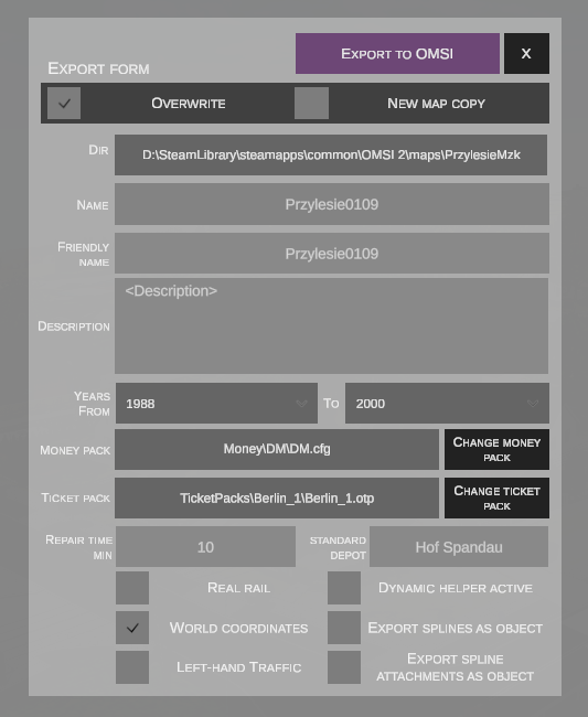
1. Save Mode (Header Toolbar)
Control buttons are located in the top-right corner of the window: * EXPORT TO OMSI (purple) – initiates the export process and generates the map files. * X (black) – closes the export dialog without making changes.
Beneath the header, select the desired save mode:
| Option | Function |
|---|---|
| OVERWRITE | Overwrites existing map files in the target directory specified in the DIR field. |
| NEW MAP COPY | Creates a new, distinct project copy under a new folder name, leaving the original intact. |
Name Conflict
If you choose to create a new map copy, enter a unique folder name where the files will be written.
2. Basic Map Parameters
The form allows you to define map metadata visible in the simulator's selection menu:
| Field | Type | Description |
|---|---|---|
| DIR (in OVERWRITE mode) | Path | Full absolute path to the target map folder in your OMSI 2 installation (e.g., D:\...\OMSI 2\maps\PrzylesieMzk). |
| DIR (in NEW MAP COPY mode) | Target folder name | Folder name for the new map copy (e.g., entering newSuperMap creates the map at D:\...\OMSI 2\maps\newSuperMap). |
| NAME | Text | Technical identifier for the map used across configuration files. |
| FRIENDLY NAME | Text | Friendly display name shown on the map selection list in the OMSI 2 main menu. |
| DESCRIPTION | Multi-line text | Description presented to the player (e.g., list of available bus lines, authors, project background). |
| YEARS FROM / TO | Dropdown selectors | Chronological year range (e.g., 1988 to 2000), determining the operational era of the map. |
| MONEY PACK | Path + Button | Path to the currency and coin configuration (e.g., Money\DM\DM.cfg). The CHANGE MONEY PACK button allows selecting an alternate pack. |
| TICKET PACK | Path + Button | Path to ticket definitions and fare tables (e.g., TicketPacks\Berlin_1\Berlin_1.otp). The CHANGE TICKET PACK button allows selecting an alternate pack. |
| REPAIR TIME MIN | Number | Average vehicle breakdown repair time on the map in minutes (e.g., 10). |
| STANDARD DEPOT | Text / File | Name of the default depot assigned to the map (e.g., Hof Spandau or a dedicated .hof file). |
3. Flags and Advanced Options
The lower section provides a set of toggles controlling terrain generation and object handling:
Left Column
- REAL RAIL – sets the
[realrail]tag in the map'sglobal.cfg. - WORLD COORDINATES – exports the map preserving real-world geographic coordinates (sets
[worldcoordinates]inglobal.cfg). - LEFT-HAND TRAFFIC – sets the
[LHT]tag inglobal.cfg(left-hand traffic for AI vehicles).
WORLD COORDINATES
This field cannot be toggled directly. If the map was created using real-world geographic coordinates, this checkbox will be automatically checked. Converting a fictional map to a real-world coordinate map is only possible via the original OMSI 2 editor.
Right Column
- DYNAMIC HELPER ACTIVE – generates dynamic driving and route navigation arrows at intersections.
- EXPORT SPLINES AS OBJECT – advanced feature converting road splines directly into static 3D objects (
.sco/ mesh). Reduces physics calculation overhead and improves FPS on dense maps. - EXPORT SPLINE ATTACHMENTS AS OBJECT – converts objects attached to splines (e.g., curbs, guardrails, lamp posts) into static scenery objects. Prevents positioning errors of
toSplineattachments on curved splines.